If you want to briefly immerse yourself in the Czech part of the national park and enjoy the highest possible view of Hardegg, this is the ideal trail for you. If you only take the asphalt road from the bridge to the lookout point and back, you can also get around here with a pram. Bonus: The exhibition in the Austrian Customs House is accessible using a code obtained from the National Park House.
Route
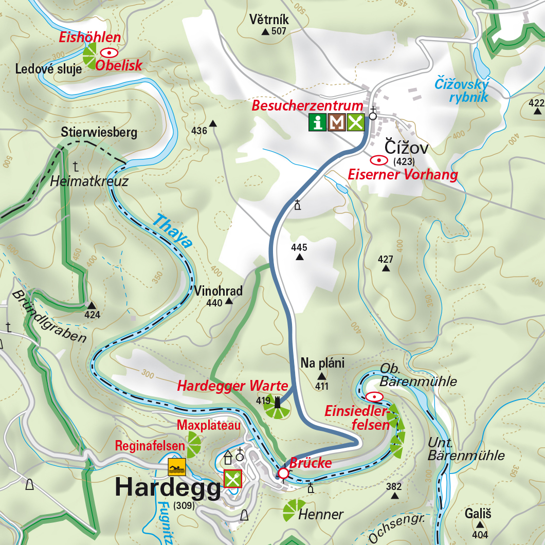
Thayabrücke customs house - across the border bridge - approx. 25 m after the border building, turn left onto the green marked trail - past the concrete bunker - follow the trail uphill to the asphalt road - on the left the road leads to the visitor centre in Čížov, on the right it leads down to Hardegg - after 1 km in the direction of Hardegg a spur trail branches off to the right to the Hardegg lookout point - return via the asphalt road downhill to the Thayabrücke.
After you pass the bridge and the customs house on the Czech side, a green-marked trail branches off about 25 metres further on. This winds upstream along the Thaya to a small creek and gives you views over the weir towards Hardegg again and again.
Follow the markings further through the forest up to the plateau, and at the edge of the forest take the path to the right to the asphalted road to Hardegg.
From here you can take a detour to Čížov, about 1 km away, where there is an information centre of the Czech Podyjí National Park and a preserved relic of the Iron Curtain.
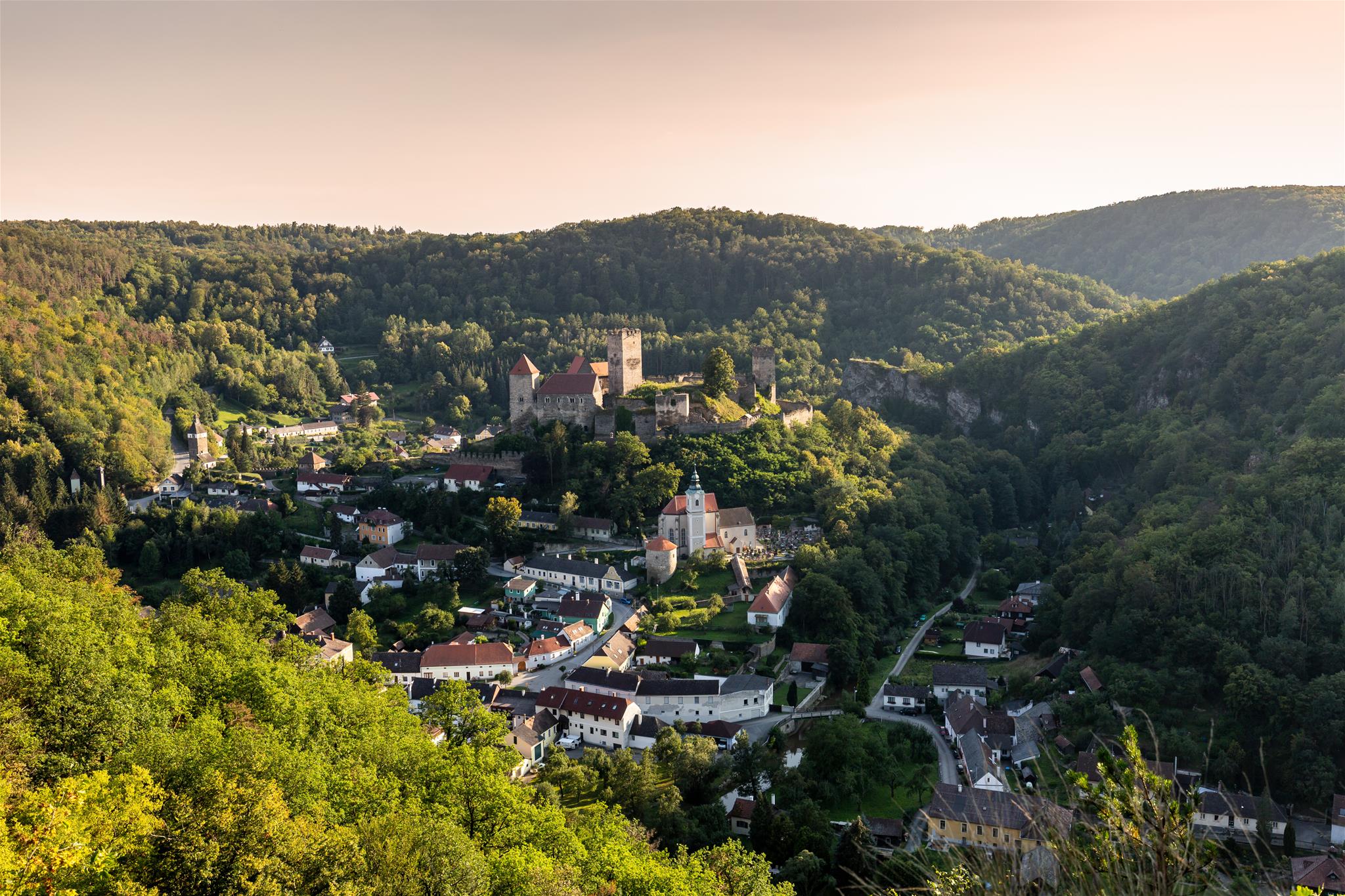
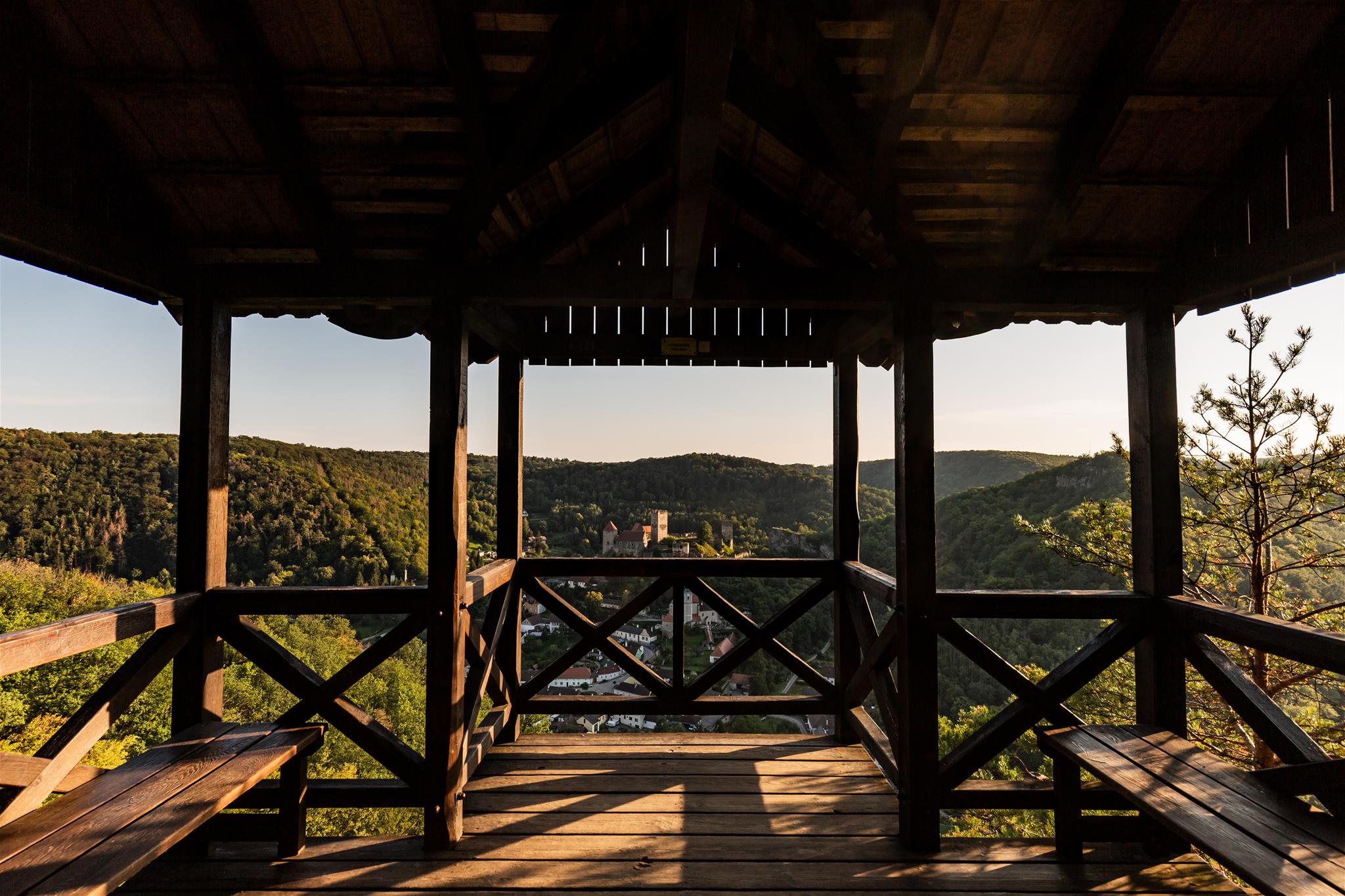
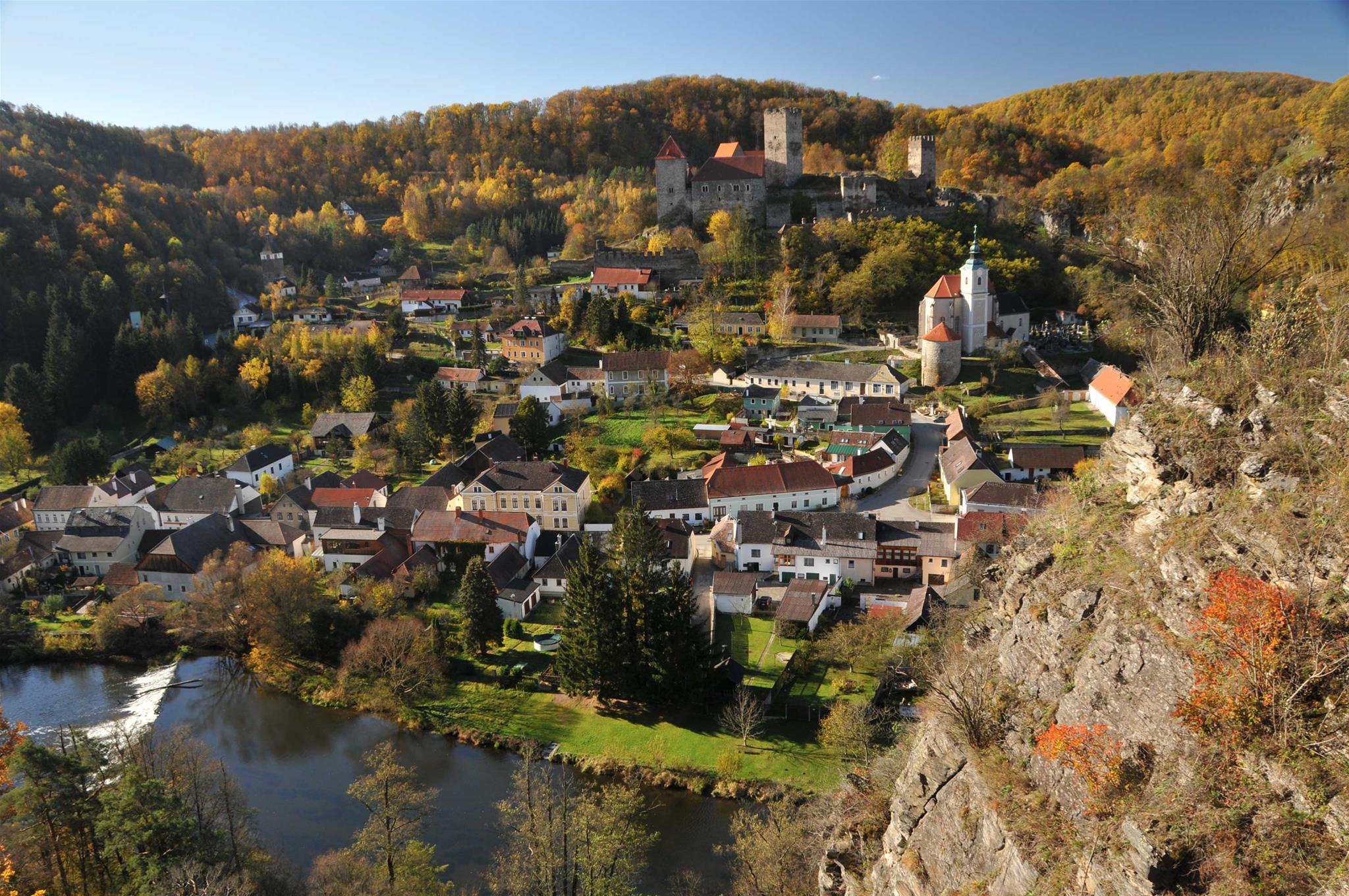
On the right, the road leads again in the direction of Hardegg. From here on, follow the blue markings. After about 1 km, an approximately 200-metre-long branch path leads through the forest to the lookout point of the Hardegger Warte. You should not miss this view of the valley and Hardegg, as the lookout stands at the highest point of this section of the valley.
Return to the Thayabrücke via the easy asphalt road.
Highlights
- Highest view of the town from the Hardegg lookout point
- Exhibition in the Austrian Customs House
Trail directions
The hike starts at the Thayabrücke in Hardegg, where the border between Austria and the Czech Republic runs right along the middle of the river. Here you will also find the Austrian customs house, which has an exhibition about the history of the bridge.After you pass the bridge and the customs house on the Czech side, a green-marked trail branches off about 25 metres further on. This winds upstream along the Thaya to a small creek and gives you views over the weir towards Hardegg again and again.
Follow the markings further through the forest up to the plateau, and at the edge of the forest take the path to the right to the asphalted road to Hardegg.
From here you can take a detour to Čížov, about 1 km away, where there is an information centre of the Czech Podyjí National Park and a preserved relic of the Iron Curtain.
On the right, the road leads again in the direction of Hardegg. From here on, follow the blue markings. After about 1 km, an approximately 200-metre-long branch path leads through the forest to the lookout point of the Hardegger Warte. You should not miss this view of the valley and Hardegg, as the lookout stands at the highest point of this section of the valley.
Return to the Thayabrücke via the easy asphalt road.
Paths steeped in history
- Today a meeting place, the Thayabrücke was an insurmountable border at the time of the Iron Curtain. A small exhibition on the nature and history of the region, which can be visited in the Austrian customs house during the summer months, tells you all about this. Important: Please ask in advance for the access code at the National Park House.
- Some concrete bunkers at the beginning of the path testify to the attempt to build protective shelters. However, the facilities built in the 1930s were never completed and are now left to decay.
Without barriers
There and back via the asphalt road, the path to the Hardegger Warte is also manageable with a pram, despite some steep sections.Important
Do not forget valid travel documents!Features and tour dates
Markings:
green (Hardegg bridge to Čížov/Hardegg road)
blue (via Hardegg lookout point back to Hardegg)
Starting point: Thayabrücke in Hardegg
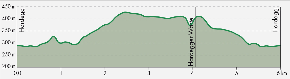
Trail length: 6 km
Walking time: 2 h
Ascent: 240 m
Descent: 241 m
Height: maximum 430 m, minimum 285 m
Difficulty: medium or easy if only via the asphalt road (blue)
green (Hardegg bridge to Čížov/Hardegg road)
blue (via Hardegg lookout point back to Hardegg)
Starting point: Thayabrücke in Hardegg
Trail length: 6 km
Walking time: 2 h
Ascent: 240 m
Descent: 241 m
Height: maximum 430 m, minimum 285 m
Difficulty: medium or easy if only via the asphalt road (blue)